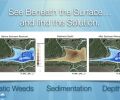
Here with Platinum Ponds & Lake Management. I wanted to show you today another bathymetry contour mapping study that we have done for one of our members. I wanted to show you what exactly goes on, you see the different red lines on a map here this is the path of using sonar were able to collect data much like a movie, recording all the depths all the way around the pond.
So we can build an underwater map, so it is very helpful in this case for us to place aeration in the correct place as well as developing some habitats. So you can see the little orange dot right here this indicates the placement of the boat and also shown here by the line on the side. You can see suspended fish, these little marks across here these are fish.
I am going to press the play button you will see the little dot start to go around the lake or pond. As we do this you will see the sonar data. The yellow line is indicating the bottom, and it has a little bit of thickness to it. You can see the depth of it is equivalent to maybe six or eight inches, and then we have these long strands that are coming up which would be dead aquatic weeds that we have killed.
In this case, we have a lot of water shield. Water shield likes a certain depth and is creeping down the side of the pond. There are some fish that are suspended in here. The dead stocks are starting to decay and fall out. So this is the path around the pond itself. So we can kind of zoom in on the pond and the boat, and we can see the equivalent of what it looks like on this side.
Now this is really where the magic happens. When we take the track off of the pond we can see the pond itself and know exactly the depths. So in this case, we have the boat dock right here, coming into the pond down the road here on to a levy.
So on this side here we always knew that was shallow because the emergency overflow was here. We didn’t know how deep it was out here in the middle, so we have a sounding board here showing the depth and the deepest portion that we were able to mark was right in this section here and it was about 8 foot right in the center. So this whole blue section in here is about 8 foot.
As you go up you have this slope that goes up into the little cut out of the pond up here. The slope is good because we want a swimming pond, and we want a deep section. The dock was placed in the exact spot that it needed to be to swim perfectly.
These areas can continue to be developed into habitats, and so we will grow the nurseries of all the small fish in these areas where they get relief from the predators and also anything else that wants to eat them.
We can also do the same thing here and that way you won’t be swimming in sticks and you won’t be swimming with a ton of tiny fish all around you. Ironically largemouth bass in particular and most fish do not stay in the deep areas of the water. Unless the bait is there and, in this case, we will attract the bait to these small areas.
Now the powerful part we can show you where shallow water and where the depth is. So everything inside of blue here is 3 feet or more. This is the area that we need to get rid of the thermocline so that we will be placing a diffuser right here and I think we can get away with another small one up in here, and we should be able to get rid of the thermocline completely in the pond. I’m essentially going to set it on fire which will make a really healthy pond.
So we can play around here a little bit with contours we can also then go into here with different layers and show you vegetation. So this is where the vegetation is, and it is creating a heat map of all of these strands that are across on the top.
We will continue to monitor these obviously the boat couldn’t get all the way up here, but we do have some up in here so we’ll continue to monitor that. Eventually, those will disappear as it decays.
We can now basically tell you the best news! Which is the composition, composition gives us basically from hard being bright red down to soft you have very few spots in here that are extremely soft, which means we’ve got very close to the bottom which means we don’t have as much to decay.
We can prove this here by the yellow line being not that thick, so we know how much sediment is in the pond as well. So hopefully, this has been
helpful it shows you what is underneath the water, and we can monitor it this way. Think of it kind like an MRI that gives us a baseline study and also gives us the next steps needed and information required to place your aeration.
So we look forward to helping you and if we can help you out check us out on the web at platinumlakes.com and certainly subscribe to all of our social media channels and find out what we are doing and how we can help you.
Now serving Greenville SC, Spartanburg SC, Asheville NC, Charlotte NC, Winston-Salem NC, & Greensboro NC areas.
Get started. Become a member today!

